COC Middle distance
|

|
Sunday, August 16
Hillsborough, New Brunswick
SCHEDULE
Registration desk open: 9:00 am
Start times: first start at 10 am - last start around 12:15
Max time allowed: 2 hours
Course closes: 2:15
Awards: 1:30 (approx)
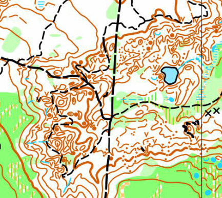
MAP SNIPPET & TERRAIN PHOTOS
Hillsborough, New Brunswick
SCHEDULE
Registration desk open: 9:00 am
Start times: first start at 10 am - last start around 12:15
Max time allowed: 2 hours
Course closes: 2:15
Awards: 1:30 (approx)
MAP SNIPPET & TERRAIN PHOTOS
|
MAP INFO
Hillsborough
ISOM
Two scales:
1:7500 for these age categories W12, M12, W14, M14, W16, M16, W75, W80, M80, W85+, M85+, W55, W65, M75, W45, M65 and the open beginner, intermediate, advanced and sport course
1:10,000 for these age categories M45, M55, W20, W35, M20, W21, M35, M21 and the open expert course
Contours: 5m
Size: 8 1/2" x 11" for both scales
Updated: Marcello Pradel, 2014
Elevation: 100m
Last major events: 2000 Eastern Canadian Orienteering Championships
Previous version of the map available here.
RULE DEVIATION
Because of the high level of contour detail in the terrain the Orienteering Canada technical committee have agreed to allow the use of 1:7,500 scale for the categories running on courses 1-6.
COURSE LENGTHS & DETAILS
Click here to see all the course details
TERRAIN DESCRIPTION
The Hillsborough map is truly awesome! A very unique and complex terrain, the result of gypsum mining many years ago. There are areas where the mining was that are now dense with sink holes - so it is a fascinating forest with technical negative terrain. Time loss is inevitable! But time loss will also be limited as you are never far from a track. There is also a variety of less complex terrain, and areas littered with a complex maze of ponds. So there will be a lot of variety in the courses, and the area will support two wonderfully enjoyable days of orienteering - the COC Middle on Sunday and the Fishbones Day 1 on Monday.
OFFICIALS
Course planner: David Ross, ONB
Controller: Jim Blanchard, OANS
IOF Event Advisor: Adrian Zissos, Calgary, Canada
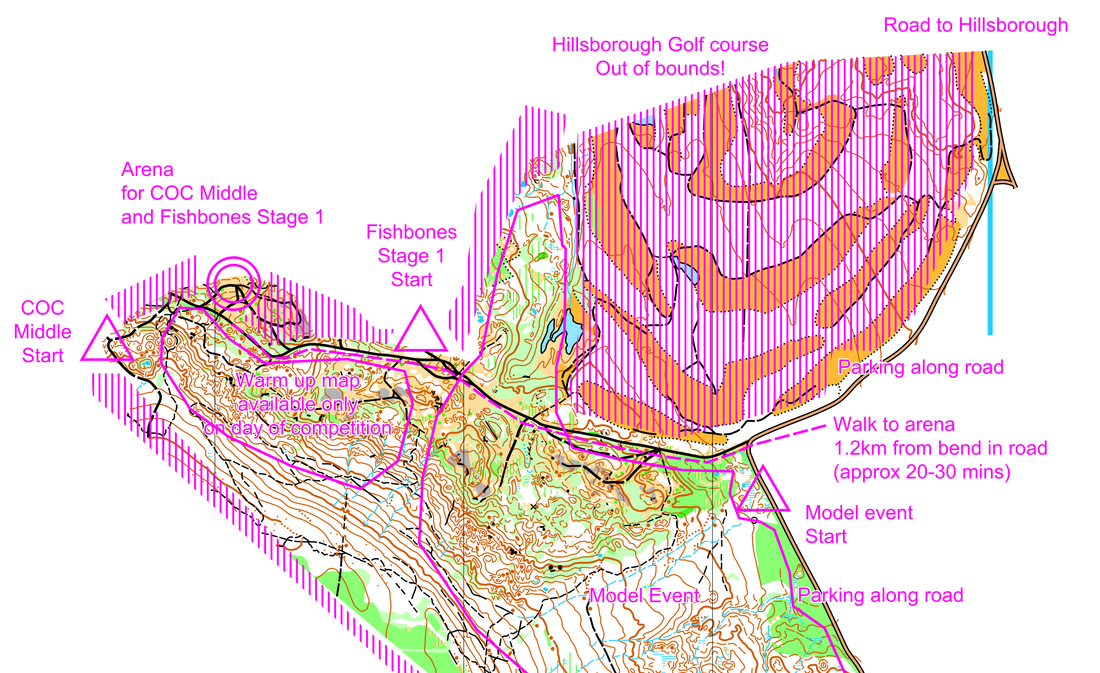
ARENA INFORMATION
Vendors: o-Store
Food: there will be limited snacks available at the finish
Water: there will be limited water available at the finish. Bring plenty with you.
Toilets: Porta potties in the arena area
Distance & Time from Arena to Start: Walk to the Middle Distance Start is 380 metres from the assembly area with a 35 m climb
Distance & Time to Arena from Parking: Parking will be along a public road, about 1.0 - 1.5km walk along a forest road to the arena (approx. 30m climb).
DIRECTIONS TO ARENA
From Moncton to Hillsborough, NB is approximately 35 minutes (30 km).
Map to middle distance
To event venues. The driving distance from the Junction of Main St. (hwy 114) and Golf Club road in Village of Hillsborough to the parking for all events is 3.5km. The Golf Club House is at kilometer 2.2 km. GPS N 45o 53.852, W 64o 39.650
Hillsborough
ISOM
Two scales:
1:7500 for these age categories W12, M12, W14, M14, W16, M16, W75, W80, M80, W85+, M85+, W55, W65, M75, W45, M65 and the open beginner, intermediate, advanced and sport course
1:10,000 for these age categories M45, M55, W20, W35, M20, W21, M35, M21 and the open expert course
Contours: 5m
Size: 8 1/2" x 11" for both scales
Updated: Marcello Pradel, 2014
Elevation: 100m
Last major events: 2000 Eastern Canadian Orienteering Championships
Previous version of the map available here.
RULE DEVIATION
Because of the high level of contour detail in the terrain the Orienteering Canada technical committee have agreed to allow the use of 1:7,500 scale for the categories running on courses 1-6.
COURSE LENGTHS & DETAILS
Click here to see all the course details
TERRAIN DESCRIPTION
The Hillsborough map is truly awesome! A very unique and complex terrain, the result of gypsum mining many years ago. There are areas where the mining was that are now dense with sink holes - so it is a fascinating forest with technical negative terrain. Time loss is inevitable! But time loss will also be limited as you are never far from a track. There is also a variety of less complex terrain, and areas littered with a complex maze of ponds. So there will be a lot of variety in the courses, and the area will support two wonderfully enjoyable days of orienteering - the COC Middle on Sunday and the Fishbones Day 1 on Monday.
OFFICIALS
Course planner: David Ross, ONB
Controller: Jim Blanchard, OANS
IOF Event Advisor: Adrian Zissos, Calgary, Canada
ARENA INFORMATION
Vendors: o-Store
Food: there will be limited snacks available at the finish
Water: there will be limited water available at the finish. Bring plenty with you.
Toilets: Porta potties in the arena area
Distance & Time from Arena to Start: Walk to the Middle Distance Start is 380 metres from the assembly area with a 35 m climb
Distance & Time to Arena from Parking: Parking will be along a public road, about 1.0 - 1.5km walk along a forest road to the arena (approx. 30m climb).
DIRECTIONS TO ARENA
From Moncton to Hillsborough, NB is approximately 35 minutes (30 km).
Map to middle distance
To event venues. The driving distance from the Junction of Main St. (hwy 114) and Golf Club road in Village of Hillsborough to the parking for all events is 3.5km. The Golf Club House is at kilometer 2.2 km. GPS N 45o 53.852, W 64o 39.650
RACE NOTES
M20, W21, M35, M21will have spectator controls
Larger trails and roads often can be used by atvs or dirt bikes while smaller trails may be used by mountain bikes. Please yield if necessary.
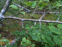
Hawthorne : there is not a lot of it, but occasionally on the map one can stumble upon very thorny Hawthorne which varies in height from a bush to a small tree. Those 5 cm thorns can be quite pesky if you get caught in them.
M20, W21, M35, M21will have spectator controls
Larger trails and roads often can be used by atvs or dirt bikes while smaller trails may be used by mountain bikes. Please yield if necessary.
Hawthorne : there is not a lot of it, but occasionally on the map one can stumble upon very thorny Hawthorne which varies in height from a bush to a small tree. Those 5 cm thorns can be quite pesky if you get caught in them.
SAFETY NOTES
The Hillsborough venue will take place on a new map, White Rock, name after the distinct white gypsum that is found throughout the area. The gypsum was mined commercially up to 1978 and shortly afterwards in 1980 it was permanently closed.
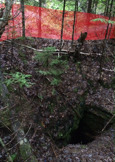
The area is physically littered with sink holes from the collapsing underground mines. The sink holes make it unique from other maps. The following are known dangers:
The Hillsborough venue will take place on a new map, White Rock, name after the distinct white gypsum that is found throughout the area. The gypsum was mined commercially up to 1978 and shortly afterwards in 1980 it was permanently closed.
The area is physically littered with sink holes from the collapsing underground mines. The sink holes make it unique from other maps. The following are known dangers:
- Caves: The caves are out of bounds. A) The roofs are unstable and B) the bats occupying the caves are endangered species and are protected. The population of bats in the area have almost vanished because of the White-Nose syndrome.
- Orange fencing: The orange fencing marks the location of openings in the ground that drop into the underground mine and holes that disappear underground. Example Vertical Mine shaft.
- Pits: There are many pits on the map. The pits are over 1 metre deep and many are over 1.4 metre deep and some over 3 metre deep.
- Depressions: There are numerous depressions in the area caused by the collapsing mine. Avoid going into them as some have unstable bottoms.
- Parking: Park only in designated parking areas. There are areas that do not support heavy loads.
Formerly gypsum mining was done. If you see orange stay out due to an open mine shaft.